Jomolhari Trek Bhutan
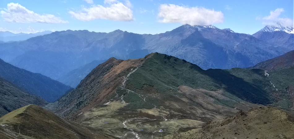


The Jomolhari trek is one of the most popular treks in Bhutan. It starts from the Paro valley and ends in Thimphu. This trek has some of the most amazing views of Mount Jomolhari (7,314 m/23,996 ft), one of the holiest mountains in Bhutan. The duration of the trek is over a period of 9 days, with the route passing through two high altitude passes, the Yale La (4,950 m/16,240 ft) and the Nyele La (4,890 m/16,043 ft), which makes this trek a bit strenuous. The best season to go on this trek is from April to June and September to November.
Mountains are earth’s undecaying monuments.
Nathaniel Hawthorne
Overview
- Destination: Bhutan
- Location: Jomolhari
- Departure: Paro, Bhutan
- Nearest City (Airport): Paro
- Highest Altitude: 4,950 m/16,240 ft
- Total Trek Distance: 133 km
- Dates: On Request
- Months: April-June, September-November
- Level: Difficult
- Guide: Available
- Price: On request
Experience
Jomolhari or Chomolhari is also known as “the bride of Kanchenjunga”. This majestic mountain peak straddles between Yadong County of Tibet and Thimphu district of Bhutan. The mountain is the source of Paro Chu (Paro River), which flows from the South side. Jomolhari is also one of the holiest mountains in Bhutan and it is believed that it is the abode of one of the Five Tsheringma Sisters – female protector goddesses (Jomo) of Tibet and Bhutan.
The trek is a beautiful mix of breathtaking views, high altitude trekking, religion and vibrant Bhutanese culture. We have added extra days for you to visit and spend time in the two bustling yet unique cities of Bhutan – Paro and Thimphu.
There are multiple itineraries through which you could see the majestic Jomolhari.
We have two itineraries for you. The first one is the classical Jomolhari Trek with additional days to explore Bhutan. The second one is shorter treks with different route yet as scenic and beautiful.
The number of days for both the itineraries could be customised based on request.
Itinerary
JOMOLHARI TREK ITINERARIES
- ITINERARY 1 - JOMOLHARI DODENA TREK: 12D/11N
- The Jomolhari Dodena trek is one of the most popular treks in Bhutan. It starts from the Paro valley and ends in Thimphu. This trek has some of the most amazing views of Mount Jomolhari (7,314 m/23,996 ft), one of the holiest mountains in Bhutan. And you could spend time in Paro and Thimphu as well.
- Day 1 / Paro
- Arrive in Paro. Check into the hotel.
- Day 2 / Paro
- Sightseeing in Paro. Hike to the Taksang Monastery (Tiger’s Nest). Visit Kichu Temple.
- Day 3 / Drugyel Dzong (2,580 m/8,465 ft) to Shana (2,890 m/9,482 ft): 15 km/2 hour drive. Trek to Soi Thangthanka.
- The ruins of Drugyel Dzong lies on the road North from Paro. At the end of the road north from Paro lie the ruins of drugyel dzong with Mount Jumolhari (7315m) behind. As we start our first day’s walk we will pass Tshento (chang zampa) where there is a small settlement which includes a Basic Health Unit (BHU) for people living far from any hospital. High up on the cliffs is a hermit building known as Chona Gompa (11,430ft/3485m). As we cross the swiss-built suspension bridge at 2485m on the way to a chorten, we will stop for lunch. Holy water from the Hedi Monastery runs on one side of the chorten. After crossing another bridge next to the Paro Chhu River, we will finally see the famous Hedi Gompa, located 200m higher and known for its large ancient statues. Soon we will reach Chobiso (2780m), where it is said that anyone gains merit by walking through the prayer wheel Chorten there. After two more hours walking your trekking permit will be checked at the military camp entrance. After another 20 minutes walking on the river side and some forest we will finally reach the big open field of Shana (2890m) where we will set camp for the night. A big snowy peak can be seen from the camp: Chatarake (Djo Drake, Jo Darkey: 6500m), which was first climbed by two dutch climbers. Note: As we have road connectivity now, so you can drive to Shana early in the morning with is 2 hours drive and than start the trekking.
- Day 4 / Shana (2,890m/9,482 ft) to Soi Thangthanka (3,575m/11,729 ft): 22 km/6-7 hours.
- Following the river up stream for a short 10 minutes, we will reach an old ruined bridge (Penji Zampa or Shana Zampa, 2878m) caused by the major floods of 1950 and 1960. This bridge was the first en route from Tibet to Bhutan mainly used by traders. On the other side of the river is Jigme Dorji National Park where different species of trees and birds are found. After trekking for 2 hrs we will reach Shing Karap (3100m) and a little further a big bridge at 3250m taking us to the east side of the river. Another five minutes and we will reach a big clearing in the forest, Thongo Samba, where our lunch will be arranged. The trek to Soi Thangthanka continues for 3-4 hrs. After some hours a bridge is crossed where you may encounter yaks. From the second bridge leading to a chorten, you might see Jomolhari to the north. The Soi Yakse valley opens up to the west with several snowy peaks between 5000m and 5650m at its end. Soi Thangthanka or Tshajeu Din Kha camp is on a big meadow.
- Day 5 / Soi Thangthanka to Jangothang (Jomolhari base camp) (4,044m/13,268 ft)
- As we enter the Soe Valley (Soe Yutey) we will be crossing the border between the Paro and Thimphu Dzongkhag (Districts). The trail will follow the river and change several directions until it reaches a military camp where trail leads to another pass into Tibet, 11km away from Phari. About an hour beyond the military camp we will reach an open meadow at an altitude close to 4000m ideal for lunch. Continuing today’s walk we will see a few small villages ahead. The Soe Yutey valley has six villages: Jomphu, Dozuden, Tikithang, Dotabithang, Dangojang and Jangothang. The population of that area is approximately 220. The first village, Jomphu, is above the actual trail. In Dangothang, two new buildings have been erected for the Jigmi Dorji National Park next to the BHU building. By now there should be a view of the spiky peak Jitchu Drake (6850m). After crossing the ruins of a dzong, decorated prayer flags and a bridge, appears the east face of Jomolhari (7315m) with its massive 3200m-high wall of granite, marble and quartzite. We have reached Jogothang, the base camp of Jomolhari.
- Day 6 / Rest day at Jomolhari camp.
- An easy day hike up the valley towards the foot of Jomolhari. The moraine-ridge walk gives a good view down to the glacier. Ahead, the east face of Jomolhari gets closer and closer. Two hours from the camp are two twin lakes Tsho Phu at 4,350m. The most challenging day hike, 3-4hrs, to reach the final rocky summit at 4,760m. The view is stunning.
- Day 7 / Day 7: Jangothang (4044m) to Lingshi (4010m) via the Nyile La Pass (4890m) Time: 5-6hrs
- The day will start with a long climb of 3 to 3.5 hours to reach Nyile La (“the sleepy pass” at 4890m). From Nyile La, the mountain Takaphu (6526m) dominates the view towards the north. Tiger mountain is the main mountain to be seen looking east. Less than 30 minutes down is a sheltered area, our lunch spot. While passing a narrow gorge with a small river crossing, you can spot Masa Gang peak in the distance. When the trail gets flat and easy, Lingshi Dzong can be seen in the middle of enormous wilderness. Exploring from Lingshi to the east side is Takaphu (6526m). At the end of this valley is a small monastery called Gyo Gompa with a dramatic view over Jitchu Drake in the background. Below the dzong is the small village of Lingzhi which has a boarding school and a BHU. The population of this village is 300-400. Lingshi has a nine-month winter and a brief summer.
- Day 8 / Lingshi to Shodu (4080m/12,385) via the Yale la Pass (4,950m/16,240 ft): 22 km/8-9 hours
- Today will be a relatively long day so we will start early. We will take a trail through a beautiful rhododendron forest on the ridge above the camp and eventually enter a valley with few trees. We will then cross the main river to its right side and climb through an area called Jimenameshing. Finally after 4-4.5 hr from our previous camp we will reach the big cairn on top of the Yale La Pass, with stunning views of the snowy mountains around Lingshi and the Basingthang Peaks to the south. Most people traveling between Lingshi and Thimphu use the Yale La, so the trail is well marked. The descent joins the Jaradinthang river, which eventually becomes the Thimphu river. At around 4150m is a chorten from where the trail takes an easterly direction following the river. The campsite is at Shodu (4080m), just after crossing a sandy slope.
- Day 9 / Shodu to Barshong (3720m/12,205 ft): 14 km/4-5 hours
- Today will be a pleasant day of hiking with not too many ups and downs. After passing a deserted military camp we will follow the trail to the river through a limestone valley. While crossing the bridge over the river, we will witness grand views of giant rock faces and waterfalls. Towards the end of the day’s walk, the trail gradually ascends to the ruins of the Barshong Dzong at 3720m below which we will set camp. The nearby Barshong village is very small, numbering less than half dozen houses. In 2001, Jigme Dorji National Park (JNDP) staff spotted a tiger and a snow leopard moving just north of village.
- Day 10 / Barshong to Dolamkencho (3,290m/10,794 ft): 15 km/4-5 hours
- Today’s walking will be quite easy with no altitude gain, only descent to the Thimphu river. After crossing a side stream, the Tshongjug Chhu river, we’ll make a steep descent on a rocky trail ending at the Thimphu Chhu river. Reaching a split in the trail, the one on the right will take us to our campsite for the night, Dolamkencho.
- Day 11 / Dolamkencho to Dodena (2,615m/8,579 ft) and Thimphu (45min drive): 7 km/3 hours
- We will start today’s walk by climbing back from the campsite up to the main trail to a cairn at 3450m, from where the route will descend to a side stream. The trail then descends through thick bamboo forests, eventually reaching our final stop, Dodena. A large sign marks one of the entry/exit points of the JDNP, and a beautiful Bhutanese-style covered wooden bridge marks the path to Cheri Monastery overlooking the valley. End of the trek. Night halt at Thimphu.
- Day 12 / Depart
- Drive to airport and departure.
- ITINERARY 2 - JOMOLHARI LOOP OPTION 1: 12D/11N
- Jomolhari Loop is the shortest of the Jomolhari trekking routes, which are the most popular treks in Bhutan. With altitude differences of 2,500m and nearly 5,000m it offers a wide range of landscapes, fauna and flora. The highlight of this trek is the spectacular view of Mount Jomolhari from Jomolhari Basecamp (Jangothang). Trekkers who want to avoid high passes and high altitude can chose an easier version of the Jomolhari Loop by retracing their steps from Jangothang (see days 1-3), while still having the majestic impressions of Mount Jomolhari.
- Day 1 / PARO
- Arrive in Paro. Check into the hotel.
- Day 2 / PARO TO GUNITSAWA VILLAGE TO SHARNA ZAMPA (2,850 m/9,350 ft)
- This trek begins at Gunitsawa Village were you pass the army post. At the army checkpost your trek permit (provided by your tour operator) will be checked and endorsed. The campsite is on the opposite side of the river, not far from Gunitsawa.
- Day 3 / SHARNA ZAMPA – THANGTHANGKHA (3,610 m/11,844 ft): 22 km/7-8 hours
- On this long day, the trail continues with lots of small ups and downs. After going uphill through the river valley the valley finally narrows gradually to a mere path which descends to a meadow where a camp will be set up.
- Day 4 / THANGTHANGKHA – JANGOTHANG (4,080 m/13,385 ft): 19 km/6-7 hours
- If you did not see Mt. Jomolhari the previous evening, you will still have a chance to get a great view early this morning. This morning the trek continues up the Paro Chhu valley which widens into patches of alpine meadow.
- Day 5 / JANGOTHANG HALT
- The rest day in Jangothang provides plenty of possibilities for day hikes with great views of lakes and snow capped mountains such as Jomolhari and Jichu Drake. There are good chances to spot some blue sheep on the upper slopes of the valley. Jangothang is a perfect environment for your acclimatization.
- Day 6 / JANGOTHANG TO SOI YAKTSA (3,800 m/12,467 ft): 16 km/6-7 hours
- The trail leads to a last settlement in the valley and drops to the Paro Chhu. Passing the lake of Tshophu (4,380m) you will climb up steeply to Bhonte La pass at 4,890 m, the highest point of this trek route.
- Day 7 / SOI YAKTSA TO THOMBU SHONG (4,180 m/13,714 ft): 11 km/4-5 hours
- The trail climbs 100m over a ridge to drop to another stream then. After crossing the Takhung La pass (4,520 m/14,829 ft) you decent to Thombu Shong, three yak herder huts with your campsite next to them.
- Day 8 / THOMBU SHONG TO GUNITSAWA VILLAGE (2,850 m/9,350 ft): 13 km/4-5 hours. Drive to Thimphu/Paro.
- Crossing Thombu La pass (4,380 m/14,370 ft) you will finally reach Gunitsawa where you can be collected or you may decide to stay at the campsite, Sharna Zampa, where you stayed the first night of this trek. End of trek.
- Day 9 / Depart
- Drive to airport and departure.
Inclusions
Inclusions
- Camping & Trekking equipments including tents, carry mat, dining tent, toilet tent, hot water bottles (when needed).
- Personally trained professional guides, cook, porter/ponies to carry equipment as well as personal luggage.
- Trekking equipment (if required) - snow boots, gaiter, crampons, ice axe, etc.
- Forest entry and permits wherever needed.
- Ground support from an experienced team of adventurers and guides.
- High comfort/luxury trek facilities.
- Food & Beverages: Breakfast, Lunch, Dinner, Tea etc. (Multi cuisine veg/non-veg prepared by well trained cooks).
- Airport transfers and transport during the trek.
Exclusions
- Any medical expenses, evacuation, oxygen cylinder etc.
- Personal clothing - incl. jackets etc., Sleeping bags (could be arranged on request).
- Any kind of Insurance.
- Personal expenses.
- Any airfare.
- Tips.
- Additional taxes.
- Accommodation in Paro/Thimphu. Could be arranged on request.
- Any payment transaction cost or fee.
- Any item not mentioned in inclusions.
Map
Book or Personalize
Its interesting, isn’t it?
Its now time to go out there and experience.
Join today.
Book Now
Hope you liked it. Do you want to request some changes and personalize the experience – in terms of date of travel, exclusive group, additional facilities and any other?If yes, then
Personalize Here

